 Kavely
Kavely help
Kavely makes walks and running loops to measure. You say what you want in a sentence, and get up to three routes to choose from. Below is what you can do and how, one subject at a time. Kavely works in your browser at kavely.app and as an app for Android; what only the app does is said where it comes up.
Planning a route as a sentence
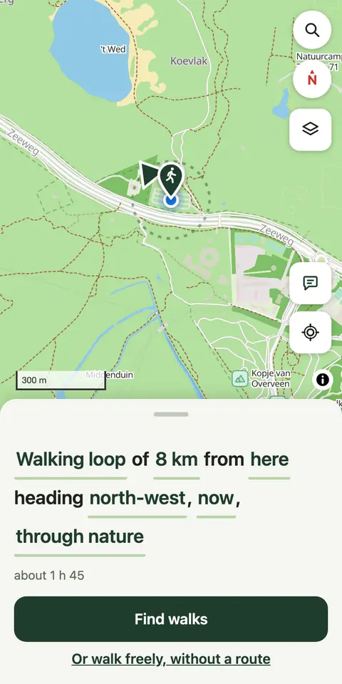
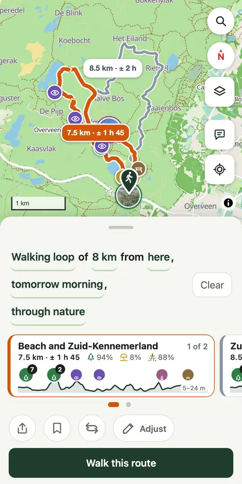
Under Plan your route reads as a sentence: “Walking loop of 8 km from here, now, through nature”. Tap a word to change it, then tap Find walks.
- Walking loop: choose Loop (you end where you started) or From here to there (you end somewhere else), and walking, running or, in the Netherlands, cycling.
- 8 km: how far, as a Distance (1 to 42 km) or as a Time (a quarter of an hour to eight hours). Kavely turns a time into a distance at your pace, and says when you'll be back and whether that is before sunset. A walking loop may come out a little shorter or longer, 30% unless you change it: 8 km becomes 5.6 to 10.4 km. How much is under More, Settings.
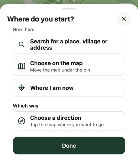
- here: where you start, which is where you are until you choose otherwise. Tap the map where you want to start and choose Start here, or search for a place, village or address, or take an earlier start or a place from your backpack. Where I am now starts from you again. From here to there, you also choose where you're going: tap choose a destination, or tap the map and then Go here. Moving the map changes neither your start nor your destination.
- now: when you go.
- nature: what you want on the way.
You get up to three different routes. If you change something in the sentence afterwards, tap Search again. Don't want a route, just a walk? Tap Or walk freely, without a route: Kavely records where you go and keeps it in your backpack.
A direction for your loop
Want your loop to head a particular way, to the sea or into the woods? Tap the word for where you start (here), and under Which way tap Choose a direction. Then tap the map where you want to go. The sentence then says “heading north-west”, for example. Any direction lets go of it again.
When you go
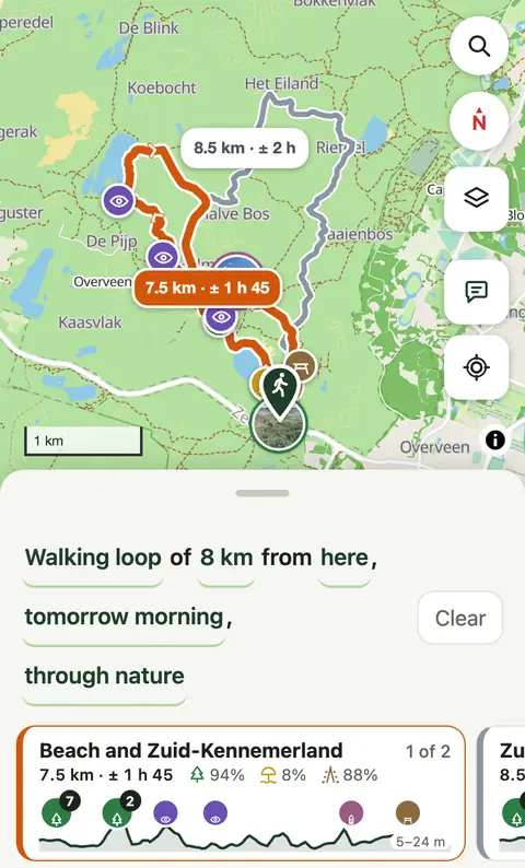
Tap now to choose another moment: This evening, Tomorrow morning, Tomorrow afternoon, or a day and time of your own, up to a week ahead. It makes a difference, because Kavely knows when paths and areas are open. Many dunes and parks close at sunset, dogs are not allowed on many beaches in summer, and a ferry does not always sail. If you still start after dark on a route through an area that is closed at night, Kavely warns you.
Below the routes you see the weather for that moment, for as long as you walk: the temperature, whether it stays dry or the chance of rain and from what time, and the wind. That goes up to five days ahead. The forecast comes from Open-Meteo.
What you want on the way
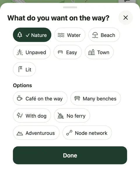
Tap the last word of the sentence, such as nature. Choose what you'd like on the way; several at once is fine:
- Nature: woods, heath, dunes; it only counts where it lies on both sides of the path.
- Water: along a ditch, river, lake or the sea.
- Beach.
- Unpaved: paths without asphalt, bricks or paving.
- Easy: few turns and as few steps as possible, easy to follow.
- Town: past monuments, churches, squares and old streets, away from cars where it can.
- Lit: paths with street lights, for walking home in the dark.
From here to there you also choose The nicest way or The shortest way at the top. The shortest way is for getting somewhere, not for the walk: as short as possible, on roads and paths you may walk, and you get one route. What else you chose falls away, except Lit, With dog, No ferry and Adventurous; closed paths stay closed. With Lit the shortest way prefers lit paths, even if that's a little further: the shortest way home in the dark.
Below them are options:
- Café on the way: past a café or restaurant somewhere halfway, usually with a toilet.
- Many benches: somewhere to sit down often.
- With dog: see Walking the dog.
- No ferry: the route goes round the water.
- Adventurous: grass paths and tracks too, which are not always there in real life.
- Node network: a loop along the numbered posts of the walking network, where there is one.
In hilly country, such as Great Britain, you also choose how much you want to climb.
Running
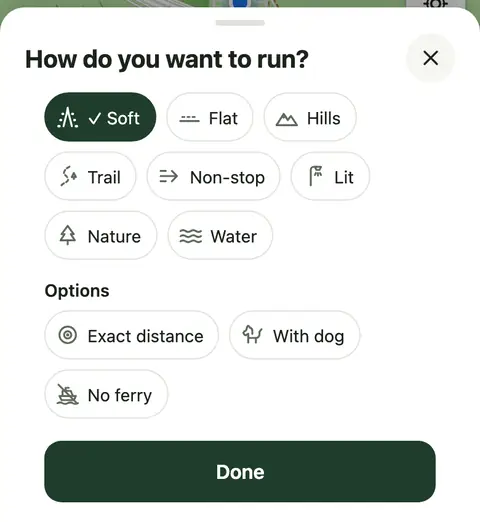
Tap the first word of the sentence and choose Run. You then choose from what runners want: Soft (unpaved but good to run on), Flat, Hills, Trail, Non-stop (few traffic lights and crossings), Lit, Nature and Water. With Exact distance a loop stays within 5% of your distance.
You set your pace under More, Settings: walking leisurely (4 km/h), average (4.5) or brisk (5.5); running easy (8 km/h), steady (10) or fast (12). Kavely works out the times with it; going up costs about a minute per 10 metres. With miles the pace is in mph, and running in minutes per mile.
On the way you hear each turn ahead and again just before it, and in the app your time after every kilometre (or mile). The map then shows only drinking water and toilets.
Cycling
In the Netherlands you can plan rides too: tap the first word of the sentence and choose Cycle. A cycling loop is 5 to 80 km, or as long as the time you choose, at 15 km/h. Kavely finds it over cycle paths and quiet roads and follows the cycle junction network (fietsknooppunten) and the LF routes where it can; unpaved paths and roads you may not cycle on stay out. You choose from Nature, Water and Lit, and with Café on the way you pass a café halfway.
From here to there you choose, as on foot, The nicest way or The shortest way. On the way you hear each turn ahead and again just before it. Outside the Netherlands cycling isn't possible yet.
Comparing routes
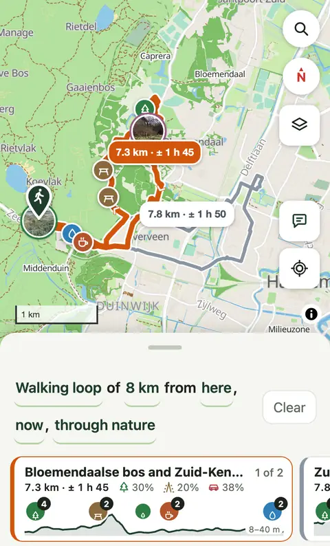
Each route has a card below the map. Swipe sideways, or tap a line on the map, to choose another. A card shows:
- the name, the distance and the time at your pace;
- what the route gives you: nature (only where it lies on both sides of the path; a meadow is open land, not nature), water (along a ditch, river, lake or the sea), unpaved (no asphalt, bricks or paving), beach, and by traffic: on or beside busy roads, a cycle path next to a fast road included;
- the elevation profile with the stops on the way; tap a group to zoom in;
- what you should know: a ferry and until when it sails, a rough stretch of path, or how much of the route is out of bounds for dogs.
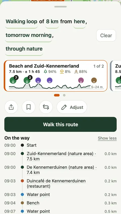
Pull the panel up for On the way: the route from start to finish with the times, the stops, a ferry, sunset and when rain is likely to set in. Tap a stop to see it on the map.
Stops on the way
Along the route Kavely shows what you'll come across: Break (café, restaurant, pub), Grab a bite (supermarket, bakery, ice cream, snack bar), viewpoints, drinking water, toilets, Shelters (weather shelters and bird hides), picnic spots, beaches, nature reserves, landmarks, churches, squares and museums, and when you zoom in, benches and art too. Walking with the dog, also Dog areas.
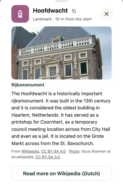
Tap a stop for more: how far it is from the start, and where Wikipedia knows the place, a photo and a few lines about it.
Where the map has a stop's opening times, the timeline and the stop say what holds when you get there: Open until 17:00, Opens at 10:00 or Closed when you get there, and for a water point that is only turned on in summer Only in summer. With Café on the way, Kavely passes over a café that the map says is closed when you get there. The times come from the map and may be out of date.
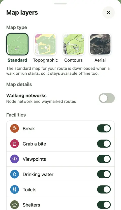
Turn off what you don't want to see: tap Map layers on the right of the map and look under Facilities.
Adjusting a route
Want to go another way? Tap Adjust, then tap the route: a point appears there. Drag it to where the route should go, or tap that spot. Only the stretch around the point changes; the rest of the route stays as it was. Tap beside the route, and it is pulled there from where it comes closest.
Your points stay on the route as numbered dots; drag them to move them again. The arrow undoes the last step, Reset brings back the route as it was. Tap Done when you're happy. Adjusting needs an internet connection.
Search
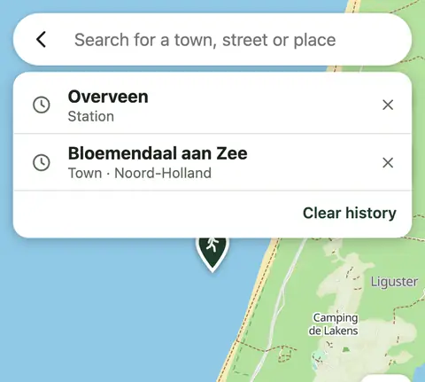
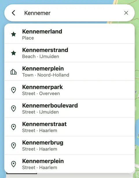
Tap the magnifier at the top right and type a town, street, address or place, such as a nature reserve, station or car park. What is nearby comes first. Tap a result and the map goes there, with a card: Start here, Go here or Save to backpack. You can also paste coordinates or a link to a map.
Before you type you see what you looked for before, each with a clock. That stays on your device only; the cross removes one, Clear history removes them all.
Your backpack
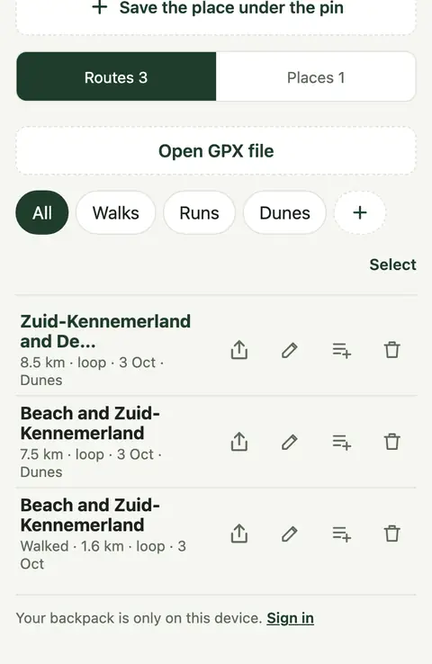
In the Backpack you keep routes and places.
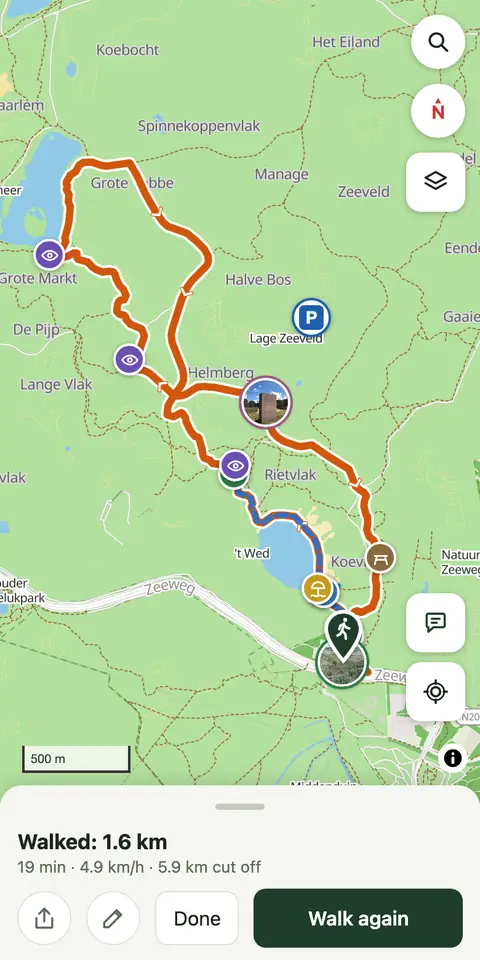
- Routes: every route you walk goes in by itself, with the track you walked. Keep a route you want to do later with the bookmark next to it. Open a walked route and you see your track over the route, how far and how long you walked and your pace; Walk again takes you round once more.
- Places: such as home or where the car is. Tap the map on the place and choose Save to backpack, or tap Save where you are now in your backpack. Use the pencil to name it, or to make it Home or your Parking spot. A saved place is then quick to choose as a start or destination.
- Lists: put routes and places in lists of your own, such as “Dunes” or “With the children”. Tap the list icon next to a route, or hold a route to choose several at once. At the top you choose which list you see; Walks and Runs show only those routes.
Without an account your backpack is on this device only. Sign in, and you have it on all your devices (see Account and privacy).
GPX files
Open a route from a GPX file in your backpack under Routes with Open GPX file; on a computer you can also drag the file onto the page. In the app you can also open a GPX file with Kavely from your files, an email or another walking app. You see the route with its percentages, can walk and adjust it, and it is in your backpack straight away. Where the map doesn't know a path, you follow the line from the file; it shows as a purple dotted line on the map.
To save or send a route as a GPX file, use Share (see Sharing a route); after a walk, the track you walked too.
In the app, share a place with Kavely, from Google Maps for example, and it becomes the start of your next route.
Walking safely
Kavely suggests a route; you decide where you walk. You are responsible for your walk and your own safety. Before your first walk the app asks you to confirm this, and under Walk this route it says so each time in one line.
- What you see on the ground comes first. Signs, gates and directions from whoever manages the land always come before the route. A path may be closed, private, or shut for a while: in the breeding season, for works or for an event.
- The map is made by volunteers. The routes come from OpenStreetMap, an open map kept by volunteers all over the world. It is good, but not everywhere and always up to date: a path may be gone, overgrown or under water. Something wrong? Report it, and the map gets better for everyone.
- What Kavely knows, and what it doesn't. Kavely works with what is on the map, and the map is complete nowhere. A few examples:
- Dogs. Kavely avoids paths and beaches where the map says dogs are not allowed, also when that holds only in summer or in the breeding season. But for many areas the map says nothing about dogs, or only part of the rules. What is not on it, Kavely does not know: look at the signs where you enter an area.
- Opening times. When a park or dunes close at night, when a ferry runs and when a café, shop, museum, toilet or other stop is open, Kavely takes from the map, where the map knows. Such times change, with the season, on holidays or out of the blue, and the map sometimes lags behind. So a ferry that runs according to Kavely, or a café that should be open, may be closed. Many places have no times on the map; about those, Kavely says nothing.
- Closures. Temporary closures, for works, in the breeding season, for events or after flooding, are rarely on the map.
- The path itself. Whether a path is muddy today, overgrown or under water, and what the tide is doing, Kavely does not know.
- The weather. Kavely shows the forecast for your route, but a forecast can be wrong, certainly hour by hour and days ahead. What you see and feel on the spot is what counts.
- Times are an estimate, at your own pace. Take enough time, water and light, and check the weather before you go. On the coast, the tide can cut off your way.
- On the way: look at the road when you cross, not at your phone. With poor GPS a direction may come late.
- In an emergency call 112, or 999 in the United Kingdom. With Sharing live someone at home can see where you are.
Driving to the start
Does your route start further away, at a car park an hour's drive off? Tap the car by Walk this route and choose how to drive there: with Google Maps or Waze, on an iPhone also with Apple Maps, and on Android with Another navigation app, after which your phone asks which app. Share… sends the start to another app, such as the Tesla app, which passes it on to the car, or WhatsApp. Where your phone cannot share, as in the Android app, it says Copy link: a Google Maps link to paste into a message. The car only shows when you are more than a kilometre from the start, or when Kavely doesn't know where you are.
Walking a route
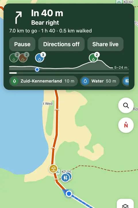
Tap Walk this route. The map follows you, and at the top are the next turn, how far and how long there is to go, and an elevation profile. The screen stays on. The map around the route is kept on your phone, so you find your way without a signal too.
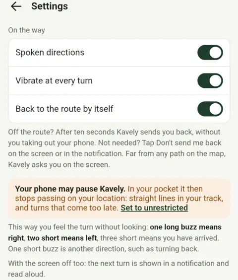
- Spoken directions: Kavely says each turn just before it. The speaker button turns the sound off and on.
- Vibrate: your phone buzzes at every turn: one long buzz is right, two short is left, three short means you have arrived.
- Pause: walk wherever you like; on Resume Kavely shows you the way back to the route.
- Directions off: Kavely says and shows nothing more, but still records where you go.
- With the compass button the map turns with you, or keeps north up.
- Stop: tap twice. Close to the end the button says Finish. The route is then in your backpack with your track.
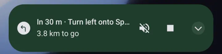
In the app all this works with the screen off too: the next turn is in a notification and on the lock screen, it is read aloud and your phone buzzes, even in your pocket. In the notification you can turn the sound off, pause and stop. Set Kavely to Unrestricted in your phone's battery settings, or Android may pause the app in your pocket and you miss turns; the app asks for it itself, and it uses hardly any extra battery. In the browser it only works while the page is open, and buzzing only on Android.
Off the route
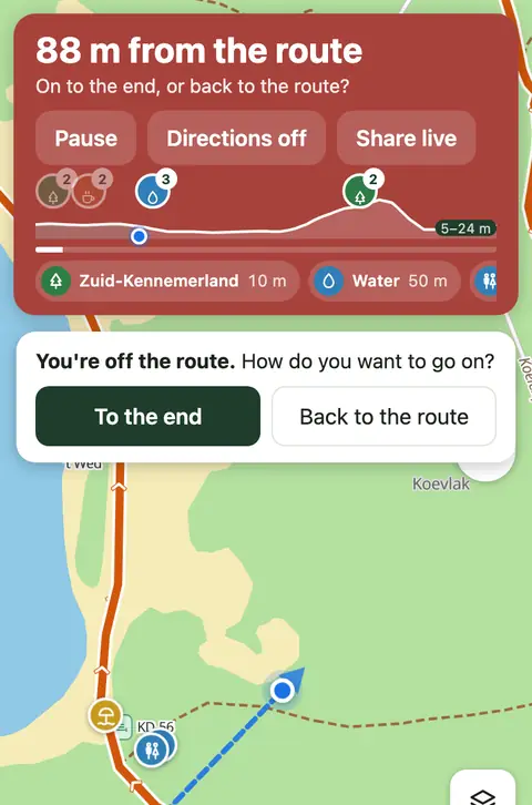
Walk more than 50 metres from the route, or take a wrong path, and you hear and see it straight away. Kavely asks how you want to go on:
- To the end: a new way from where you are to the end.
- Back to the route: the way back to your route.
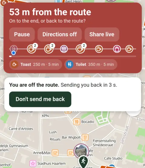
In the app (from version 1.2.0) you can turn on Back to the route by itself under More, Settings. If you leave the route, Kavely says it will send you back, and after ten seconds it shows the way back, without you taking out your phone. Don't want that? Tap Don't send me back on the screen or in the notification. If you are far from any path, have not been on the route yet, or go your own way again just after being sent back, Kavely asks you on the screen.
Sharing live
Let someone see where you are. On the way, tap Share live and send the link. Whoever opens it sees your route, a red dot where you are, how far you still have to go and when your position last came in; they need no app or account for it. Sharing stops when you stop walking, with Stop sharing, or after four hours. Only your last position is kept, and it is wiped as soon as sharing stops.
In the app (from version 1.2.0) sharing goes on with the screen off; in the browser only while the page is open.
Walking the dog
Turn on With dog among the options (tap the last word of the sentence). Kavely then avoids paths and beaches where dogs are not allowed that day: in many nature reserves all year round, on many beaches in summer. If that can't be done entirely, the card says how much of the route is out of bounds for dogs. On the way you see Dog areas, and a route that passes one is preferred. With a dog Kavely works with a slightly slower pace.
Sharing a route
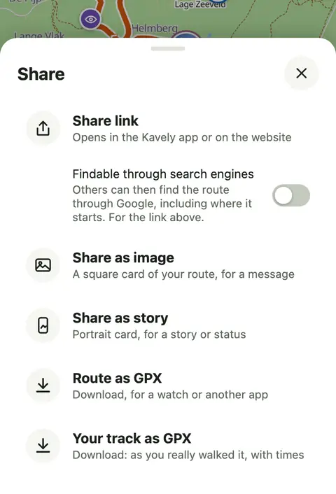
Tap the share icon next to a route, in your backpack or after a walk.
- Share link: a link to the route. Whoever opens it sees the route on the map and can walk it; on Android it opens in the app, if it is installed. In chat apps it shows a preview with a little map. With Findable through search engines, search engines may show the route too.
- Share as image or Share as story: a picture with the map, the name and the numbers; after a walk, with your track. Words are ready to paste beside it, with @kavely.app in them: on Instagram that becomes a tag, and we get to see your walk. Follow Kavely on Instagram.
- Route as GPX, and after a walk also Your track as GPX: for another app or your watch.
Reporting a problem
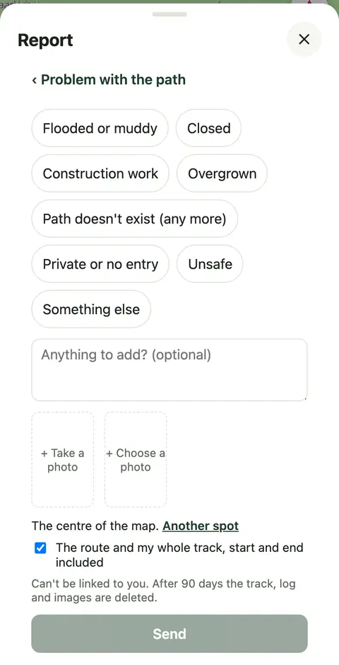
Is a path flooded, closed or gone? Or does the app do something odd? Tap the speech bubble on the right of the map: Report a problem. Choose Problem with the path, Problem with the app or Something else, write what is wrong and add a photo if you like. Kavely sends where it is: where you are, or the middle of the map; Another spot lets you choose. Leave it ticked, and the route you're looking at goes along too. We read every report. It is not linked to you, unless you send your account with it.
Account and privacy
Kavely works without an account. To have your backpack on more devices, tap Sign in under More. Enter your email address; you get a six-digit code that works for a quarter of an hour. There is no password. From then on your routes, walked tracks, places and lists are on all your devices. On the account page you see your devices, download your data and can delete your account.
Kavely has no ads and no trackers from others. Without an account your location, your tracks and your backpack stay on your device. It is all in the privacy policy.
Language, countries and maps
Kavely speaks Dutch and English: choose under More, Settings, Language (in the app from version 1.2.0). There are routes in the Netherlands and the United Kingdom; the node network only in the Netherlands.
Below it, under Distances, you choose Kilometres or Miles: with miles, distances are in miles and yards, the pace in mph and heights in feet. Until you choose, Kavely goes by your phone or browser: set up for the United Kingdom or the United States, with its clock on the time there, it uses miles; otherwise kilometres. A Dutch phone set to English keeps kilometres. Spoken directions in miles are in the app from version 1.2.0.
Under Map layers you choose the map: Standard, Topographic, Contours or Aerial (outside the Netherlands Satellite), whether to show walking networks, and whether the map shows photos of sights: the best known in view, even zoomed far out, to discover where you'd like to go.
As soon as you start walking, Kavely keeps the map around the route on your phone, with the texts about the stops: about 2 MB for 8 km. So you find your way without a signal too. That is the standard map; after the walk it goes again.